Waterways
The Port of St. Louis encompasses 70 miles of waterway from Jefferson County, Missouri in the south to Madison County, Illinois in the north. It is served by eight port authorities, including the Southwest Regional Port District and the St. Louis County Port Authority, among others. [1] The city of St. Louis is situated right below the convergence of the Missouri and Mississippi Rivers, two major U.S. rivers that together flow over 4,500 miles and connect 15 states.


Figure 1: St. Louis Port in 1852. Figure 2: The port in 1904. Figure 3: Mississippi River South of St. Louis. Source: Steamboat Times [2] Source: Missouri History Museum [3] Source: City of St. Louis Missouri [4]
Its location at the intersection of these two waterways made St. Louis great territory for Native American settlement as well as a prime trading post as settlement increased in the 1800s. The steam-powered boat enhanced river travel which further increased St. Louis’ maritime importance. Cities like New Orleans, Kansas City, and Pittsburgh were only a couple days travel away and the ability to transport raw materials and the finished goods back more quickly made the crossroads of St. Louis even more prosperous. By 1846, during the “Golden Age of Steamboating” of the 1840s-50s, 1200 steamboats were on the Mississippi with up to 50 being able to dock in St. Louis. [5]
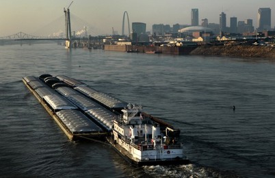 Figure 4: Barge traveling into St. Louis. Source: stltoday.com [7]
The growth in the use of trains and airplanes significantly impacted waterway transportation by providing even quicker means of long-distance travel. Although passenger travel by boat has declined, transportation of goods over waterways remains prominent when combined with railways and trucks. This is due to a barge’s capable load of around 1500 tons, which comparatively would require 60 trucks or 15 train cars to transport the same capacity. By the mid 2000s over 32 million tons of products passed through the port annually, which made St. Louis the third largest port in the country in terms of tonnage. At the city terminal, a 90,000 foot and 20,000 foot warehouse take care of much of the demand, where commodities can be reportedly transferred from barge to truck in 18 seconds. [6] Rail yards along the banks of the port also aid the quick flow of goods. Waterways coupled with rails and trucks allow freight to be moved as quickly and cheaply as possible, and St. Louis plays a major part in the flow of U.S. commodities.
References:
[1] U.S. Army Corps of Engineers. "The Port of St. Louis, Missouri, and ports on upper Mississippi River, miles 0 to 300 AOR." Port Series, no. 70 (1992).
[2] Steamboat Times. Accessed August 31, 2014. http://steamboattimes.com/images/levee_scenes/stlouis_levee1852thomas_easterly1600x1224.jpg.
[3] "St. Louis Levee from Eads Bridge." Missouri History Museum. Accessed August 31, 2014. https://www.flickr.com/photos/mohistory/3290121497/.
[4] "St. Louis Port Authority." The City of St. Louis Missouri. Accessed August 31, 2014. https://www.stlouis-mo.gov/government/departments/sldc/images/CarondeletCoke_2.jpg.
[5] "Part I: Transportation." The City of St. Louis Missouri. Last modified 2011. Accessed August 28, 2014. https://www.stlouis-mo.gov/government/departments/planning/cultural-resources/preservation-plan/Part-I-Transportation.cfm.
[6] St. Louis Regional Chamber & Growth Association. "River Transportation through and to St. Louis." stlcommercemagazine. Last modified 2005. Accessed September 1, 2014. http://www.stlcommercemagazine.com/archives/march2005/river.html.
[7] "Port expert: St. Louis should partner with coastal port." stltoday.com. Accessed August 31, 2014. http://www.stltoday.com/business/local/port-expert-st-louis-should-partner-with-coastal-port/article_6c24674a-7f3d-5e4a-a22c-7a259c6710ed.html.
