Adopted urban planning designs in the last decade
During the last decade, St. Louis and neighboring suburbs have seen a decrease in population. However the new corridor, built in 2008, from the Arch and the eight miles west of the Arch that was built is reversing this decrease. The corridor stretches from the riverfront to Interstate 170 and contains many offices, companies, medical research centers, museums, plays and concerts, restaurants, court, mass transit and bars. There are a wide variety of homes from apartments to modern houses, to grand estates. The increasing fields of life-science research and health care are the main causes as to why this area of St. Louis is flourishing and continuing to grow. There has been an increase by more than ten percent in the amount of residents in this area which shows that living in the city does have its perks: more walking and less driving. The area is also expanding and encouraging multiple new businesses to enter the area that will in turn keep the area booming. [11]
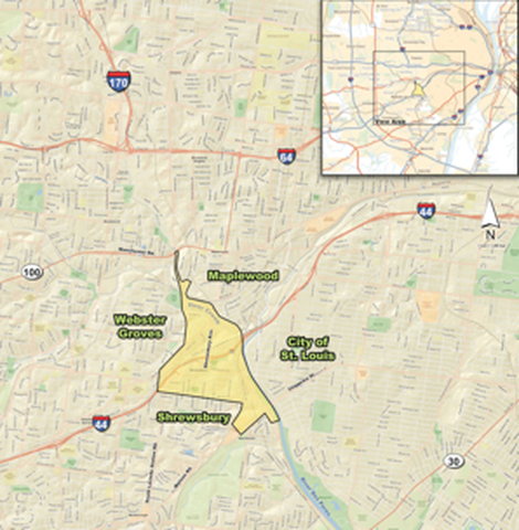 Figure 4: South County Connector "Area of Influence", source: cnu.org
St. Louis has the ability to expand because of the use of the MetroLink system that replaced the old streetcar lines. The transit serves the east-west corridor and the Central West End station is located by the Washington University School of Medicine, which is expanding due to a one billion dollar grant. The Partnership for Downtown St. Louis wants to expand the streetcar line in the area from downtown to the Central West End which would encourage development as seen in Figure 4. [12] There are currently two projects in St. Louis hoping to transform transportation in the city; proposed removal of I-70 and a South County Connector. I-70 may be removed and replaced with a boulevard that allows pedestrian use. The interstate created a divide between the city and the river front. This section of the highway is the least used and can easily be rerouted. The National Park Services created a general management plan which resulted in a design competition. There has been requests to remove sections of I-70 in order to revitalize the riverfront area in downtown by turning the interstate into a boulevard. A volunteer group, City to River, is compelling a list of substantial benefits this conversion would have for the city. The South County Connector project is designed to improve congestion, enhance interstate connectedness and increase mobility throughout south St. Louis County, the City of St. Louis, and central St. Louis County [13]. The project is being reviewed by the Environmental Impact Statement submission process.
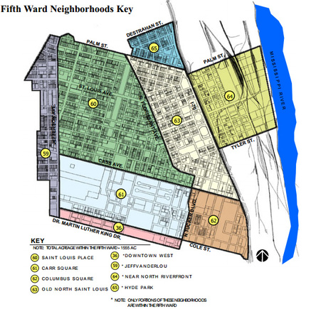 Figure 4: Fifth Ward Neighborhoods Key Source: The City of St. Louis Missouri [14]
In the last decade, the Planning Commission of St. Louis has adopted quite a few urban planning projects. The Neighborhood Plan for the 5th ward was adopted on March 6,2002 which includes the areas of St. Louis Place, Carr Square, Columbus Square and Old North St. Louis, noted in figure 5. [14] The Fifth Ward is north of downtown St. Louis and contains 1500 areas. The area has seen a decline of residents over the past years and the census has shown that fewer and fewer kids are living in the area, suggesting that families are not moving into the area and the population is growing older. The goal of the project was to enhance the community by providing social outlets for all ages and all styles and prices of homes, creating a self-supportive town and a clean community, while protecting the already existing layout and using transportation as a resource in hopes to attract more residents and tourists.
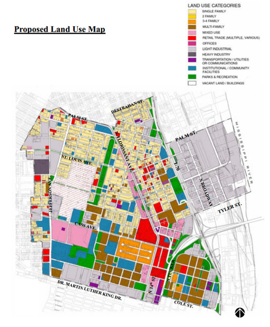 Figure 5: Proposed Land Use Map Source: City of St. Louis Missouri [15]
The design process had multiple “catalyst” projects that will stimulate growth and development in the area. The areas in which design projects were proposed can be seen in figure 5. [15] Boulevard and streetscape improvements were first on the list because these types of improvements can show instant impact for the community. Next on the list was a retail area along North Florissant Avenue,Old Historic North St. Louis, which include a grocery store, restaurants, Movie Theater, retail stores and office spaces to bring in new businesses, jobs, tourists, etc. There was also transformations of large land areas that must respect surrounding uses of land, i.e. schools, neighborhoods, etc. In the Carr Square area there is a larger number of multi-family housing resulting in more multi-family homes to be built along with schools, parking and parks. The area was not suitable for single family homes or other single family developments so the planning commission decided to stick with multi-family needs. In the Columbus Square Neighborhood0 there isn’t much room for expansion and is the closet area to the heart of downtown, attracting a large number or residents looking for an urban lifestyle. There were plans for more multi-family living as well as transportation improvements to make the area self-supportive and more desirable. The plans complimented the already existing block geometry of the city. In the St. Louis Place Neighborhood, 45% of the land was vacant and is home to mostly single family households. By using transitional zoning designations, the plans for the neighborhood included the extension of the MetroLink for North Florissant Avenue which will lead to more development; commercially, residentially, and mixed use. In the Old North St. Louis neighborhood there was development along the North Florissant Corridor which increased demand in the housing market, retail development, and development of housing units. A mall was also created on 14th Street to bring in new business and dinning and allowed for the community to reinvest in the area.
Within the proposal there were also plans for park and streetscape revitalizations as well as transportation improvements and additions. Pocket parts were added near the bridge at Columbus Square, and a new park within the square, new park alongside I-70, a family learning center off Carr Street and a park at the intersection of Jefferson and Parnell. Multiple streets in the city had streetscape improvements and development. The new Mississippi River Crossing will land in the Ward allowing for better flow of traffic even though a few buildings and businesses will be taken down due to the construction of the bridge. However to counter this set back, the new bridge brings in new business to the area. [17]
Within the proposal there were also plans for park and streetscape revitalizations as well as transportation improvements and additions. Pocket parts were added near the bridge at Columbus Square, and a new park within the square, new park alongside I-70, a family learning center off Carr Street and a park at the intersection of Jefferson and Parnell. Multiple streets in the city had streetscape improvements and development. The new Mississippi River Crossing will land in the Ward allowing for better flow of traffic even though a few buildings and businesses will be taken down due to the construction of the bridge. However to counter this set back, the new bridge brings in new business to the area. [17]
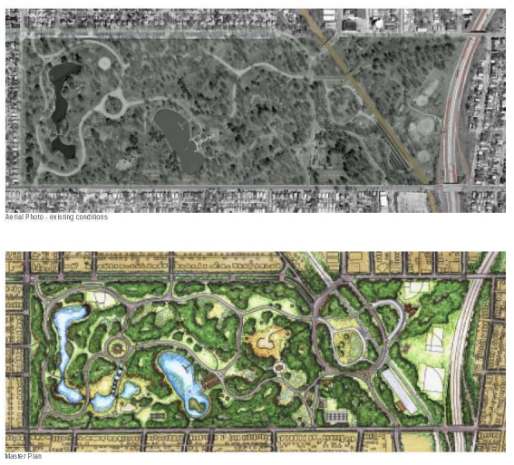 Figure 6: Existing Conditions and Master Plan Source: City of St. Louis Missouri [18]
On April 2, 2003 the Carondelet Park Master Plan was adopted to address the deteriorating state of the park. The 180 acre park is in the Southern part of the city and is in a ten minute drive of about 36,000 residents. The park has athletic fields, ponds to fish, historic landscape and architecture and hosts events such as concerts. The city wants to transform the park into an area the community can gather together, to be able to host events, and an environmentally safe area for sports and all other community activities. While at the same time, protecting the ecosystems and resources present at the park. To accomplish these goals, the planning commission improved the accessibility of the park to neighboring communities and revamped the Karst landform and creek area of the park. They used the existing sinkholes to provide aquatic areas that helped habitats and the drainage and water quality of the park. They improved the roads and managed traffic in and out of the park by diverting cut through traffic. The plan moved the recreation activities to the west end of the park and built biking and walking trails throughout. They moved the park maintenance facility next to the rail lines in order to reuse the historic stables that it once built on. Figure 6 is an image of what the park looked like before and after the renovations, including water, landscaping, and field designs as well as park paths and entrances. [18] Overall the plan modified and improved all historic landmark and refurbished landscaping throughout the entirety of the park. [19]
The Downtown Development Action Plan created by Downtown Now! was adopted in December of 1999 in order to revive the downtown districts of St. Louis economically, politically and socially. The plan had a 1.12 billion dollar budget to create a model for future downtowns and to be able to compete in the New Economy. In figure 7, proposed areas and ideas are listed on a map of downtown. [20] By 2004, the goals of the plan were to:
· Bring in more residents in order to boost the economy and environment
· Intertwine businesses, stores and restaurants
· Pants, work environments, etc. into the downtown atmosphere
· Build new parks and plazas connected together through walkways
· Create an easy to use grid of streets and pedestrian walkways and bike paths to make downtown more cohesive
· Offer a human friendly environment
· Make sure the Mississippi River Bridge is used as a facilitator in boosting the economy and development of the city
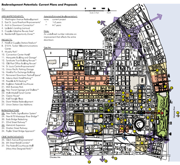
Figure 7: Redevelopment Potentials: Current Plans and Proposals Source: City of St. Louis Missouri [19]
In order to accomplish the goals set, the planning commission needed to build more housing for about 10,000 additional residents and 500,000 more square feet of office space in the heart of downtown. Along with new residential areas and office spaces, the city had to add more parking, security, and traffic controls. In order to revive the economy, the city had to real in more businesses to fill in the new spaces and add more attractions for tourists who were visiting downtown. To address the increased flux of people in St. Louis the planning commission enhanced streets and sidewalks. Specifically, the plan called for:
· Tree planting in the Downtown Core to improve the streetscape
· Improvements to the Gateway Mall to improve its landscape investment and physically connected it to the Arch Grounds
· Repurpose the Old Post Office that was abandoned into an educational center
· Add new residential areas
· More open spaces and trails throughout the city to make city more walkable and furnished the trails with benches, lights, and trash cans to make the areas unified
· Adding a landscape deck to the unused lanes on I-70 between the mall and the Arch Grounds
· Added new parking to support new development
· Added new aesthetically pleasing elements to the Mississippi river Bridge and 22nd Street Corridor to make them more uniform and connect better with Downtown
· Added more landscaping to the freeways that led into the City to show more pride [20]
Figure 8 shows where these proposals took place in the City. [21]
[11] Bryant, Tim. "Anchors and transit spur growth of St. Louis corridor." T. Louis Post Dispatch. N.p.,n.d. Web. 21 Aug. 2014. <http://www.stltoday.com/business/ local/anchors-and-transit-spur-growth-of-st-louis-corridor/article_f095688e-
11b9- 5819-9bc7-14292595c47a.html>
[12]"South County Connector 'Area of Influence.'" Congress for the New Urbanism. N.p., n.d. Web. 21 Aug.2014. <http://www.cnu.org/highways/stlouis>
[13] "Highways-To-Boulevards Campaign: St. Louis." Transportation Summit. N.p., n.d. Web. 20 Aug. 2014. [14]"5th Ward Neighborhood Key." City of St. Louis Missouri. N.p., n.d. Web. 1 Sept. 2014.<https://www.stlouis-mo.gov/government/departments/planning/documents/
upload/Nhd5th_exec31.pdf>
[15]"Proposed Land Use Map." City of St. Louis Missouri. N.p., n.d. Web. 1 Sept. 2014. <https://www.stlouis-mo.gov/government/departments/planning/documents/upload/Nhd5th_exec31.pdf>
[16] Missouri. Urban Planning Commission. Planning Commission. 2002 Gen. Assem. The City of St. Louis Missouri. Web. 21 Aug. 2014. <https://www.stlouismo.gov/government/departments/planning/documents/upload/Nhd5th_exec31.pdf>
[17]"Existing Conditions and Master Plan." City of St. Louis Missouri. N.p., n.d. Web. 24 Aug. 2014.<https://www.stlouis-mo.gov/government/departments/planning/documents/upload/CPmaster-plan-02-03.pdf>
[18]Schnapp, Andrea. "Carodenelet Park Master Plan." City of St. Louis Missouri. St. Louis Department of Parks and REceration, 2003. Web. 21 Aug. 2014. <https://www.stlouis-mo.gov/government/departments/planning/documents/upload/CPmaster-plan-02-03.pdf>
[19]"Proposed Areas of Focus." City of St.Louis Missouri. N.p., n.d. Web. 24 Aug. 2014.<https://www.stlouis-mo.gov/government/departments/planning/documents/ upload/DowntownDevelopmentActionPlanPart1.pdf>
[20]"Downtown Development Action Plan." The City of St. Louis Missouri. N.p., n.d. Web. 29 Aug. 2014. <https://www.stlouis-mo.gov/government/departments/planning/documents upload/DowntownDevelopmentActionPlanPart1.pdf>
[21]"Proposed Areas of Focus." City of St.Louis Missouri. N.p., n.d. Web. 24 Aug. 2014.<https://www.stlouis-mo.gov/government/departments/planning/documents/upload/DowntownDevelopmentActionPlanPart1.pdf>
