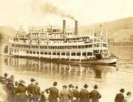
Figure 1: The East St. Louis Coming Into Dock
Source: Bing.com [2]
|
the first general plan |
The City of St. Louis was “planned on the grid-iron system, with open spaces at isolated points and the great waterway, the River Mississippi, forming the eastern boundary” [1]. With these great features already established, shortly after the World Fair, inspiration grew for a formal master city plan to be drafted. “A City Plan for St. Louis” was produced in 1907 by the Civic League headed by Henry Kent. Six committees including 42 citizens who represented almost every profession and interest were part of the process. Many professionals who were interested in Progressive Movement causes also contributed their ideas that included model tenements, health and sanitation standards, charter revision, public bathhouses, and city playgrounds, following a grid format. [3]
|
The 1947 comprehensive plan
As decades went by some of the elements of the first plan were implemented while others were not. After having gone through a period of war, Harland Bartholomex took responsibility of drafting another general plan. In 1947, a comprehensive plan was completed and became one of the most important plans for this city due to its concepts which looked far into the future. While some people criticized the plan, it continues to have an impact on the city of today because of the needs the plan identified such as urban renewal and highways. Below the 1947 Comprehensive Plan is briefly outlined [4].
introduction
At this time, the city was predicted it would have a population of 900,000 by 1970 which would mean there would be a need for new roofs, adequate traffic ways for the increase in autos, economical plans for public and semi-public facilities and improvement in all that was neglected during the war period. The goal became to plan for a more efficient and attractive city through zoning, restraining every group to particular areas to prevent chaos.
|
|
The METROPOLITAN community |
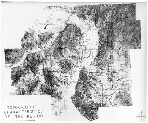 Figure 2: Topographic Characteristics of the Region
Source: The City of St. Louis [5]
Figure 2: Topographic Characteristics of the Region
Source: The City of St. Louis [5]
St. Louis covered 62.4 square miles, had about 100 incorporated communities, 500 school districts, and 100 other special sewer, drainage, park and other districts at that moment. Their terrain had low level areas near the rivers that gave the opportunity for unlimited industrial expansion and gently rolling uplands that offered a splendid residential area. Urban use made up less than one-fourth of total area of the District, agricultural purposes made up one-half, and undeveloped land made up one-fourth.
Population
Planning for the future required certain assumptions to be made for guidance, one being that the population would continue to maintain its present proportion to total urban population of the US. They also assumed that an attractive environment for living would be developed to counteract decentralization trends, and that the city would be a maturing urban center that could never expect to attain the tremendous growth of past periods.
|
|
Land use and zoning |
The plan identified the need for land use to be sharply defined with each area having ample room to implement improved standards of design, arrangement, and open space. This was especially necessary after the Zoning Ordinance of St. Louis of 1918 was held unconstitutional in 1923; its main deficiencies included no single-family dwelling district, no population density regulations, insufficient residence area, twice as much land zoned for commerce, more than twice as much for industrial purposes, and obsolete and inadequate text regulations. The new proposed zoning ordinance would fix these problems by dividing the city into eleven districts with specific use, have population density regulations, height limits in residential and commercial areas would be reduced, there would be off-street parking space for dwellings, assembly halls, and hotels, off-street loading for commercial and industrial buildings, downtown businesses would be zoned as the Central Business District, and many other changes that would greatly improve the development of the city.
housing
The plan was honest and stated that for these reasons St. Louis was not a good place to live; $4,000,000 general tax funds were spent annually to maintain obsolete areas, 33,000 dwellings were still dependent on outside privy vaults, an additional 25,000 dwellings had toilets that were shared by several families, 82,000 dwellings had structures built before 1900, obsolete and blighted districts resulted from focus being placed on the newest and latest houses while these earlier homes were left to deteriorate, there had not been a Housing Policy and no Housing Program either. The plan understood that many people had to endure poor housing conditions and identified plans for change. Reconstructing obsolete areas, improving living standards in blighted districts by specifically enacting a Minimum Standards Housing Ordinance, and zoning all became priorities.
|
|
streets and trafficways |
Annual traffic was expected to increase from 1,531,000,000 to 2,403,000,000 vehicle miles by 1960 which could not be accommodated for unless there was new and enlarged flow channels with regulation and control. They decided that four main types of major streets and traffic ways would be necessary; secondary streets of four lanes, major streets of 6 lanes, major streets of 8 lanes, and express highways. Included also was a requirement for building lines for economical purposes to assure sufficient street capacity, local expressways that would alleviate some of the heavy traffic, a loop in the business district, and major streets that would provide access between highways and principal sections of the city.
public recreation facilities
At this time there were mostly only large parks in St. Louis and a lack of neighborhood parks and playgrounds. There was only one acre of park for each 263 persons and the goal became to double park acreage for the future. The aim was to have one park for every residential area, with only local traffic allowed to enter the area as a way to promote public safety, peace and quiet in the center of the neighborhood. The plan also indicated expansion and reconstruction of the school program to create larger sites and place them in improved locations; despite, the city did have notable design and construction standards.
|
|
mass transportation |
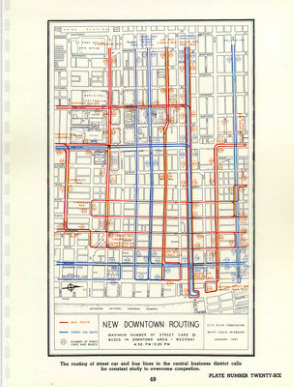 Figure 3: New Downtown Routing Source: The City of St. Louis [4]
About 88 per cent of the total area of the city and 99 per cent of the total population was being served directly by streetcar lines or bus lines. These were the dominant means of transportation for entering and leaving the central business district. To facilitate traffic in this area, curb parking for autos would have to be completely prohibited throughout the day. However the plan pointed out that mass transportation facilities had done well in keeping up with the city’s needs through the numerous street openings and widenings that had allowed direct routing and reduced travel time.
air transportation
As autos increased during this time, air transportation did as well. The proposal was for 35 airfields that included major airports, secondary airports, minor fields, local personal fields, and congested area airports. Two minor, one private and two congested areas airports would be placed specifically in St. Louis, noting that having a private airport would signify a concentration of potential private plane owners nearby.
|
|
the central business district |
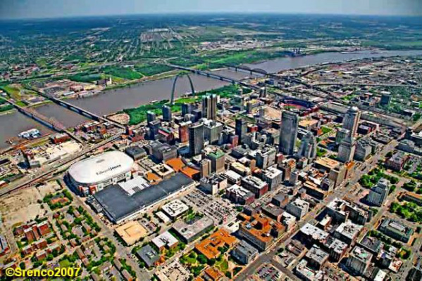 Figure 4: The Central Business District
Source: Srenco (2007) [6]
Figure 4: The Central Business District
Source: Srenco (2007) [6]
This has been and continues to be the heart of the city and the focal point of the plan. Development was crucial to this area because with rising populations, congestion increased from an increase in number of buildings, stores, shops, hotels, and other buildings, auto and truck traffic, and an inability to widen narrow streets. If regulations were not established public convenience would be impaired for the approximately 375,000 persons that entered the business district between the hours of 7am and 7pm. In comparison, Chicago, Los Angeles, Boston, and Detroit were able to support larger business districts and larger populations indicating the need for rapid transit facilities and control of pedestrian traffic. Private autos were only beginning to increase but already consumed six to eight times as much street space per passenger as public vehicles and parking space was imperative. Traffic flow had to be maximized in all its capacities.
carrying out the comprehensive plan
The first official City Plan Commission was appointed in 1912, yet they were ineffective in carrying out some elements of the first general plan and in also making a new one. Improvements were not made unless citizen groups responded aggressively and because of inadequate knowledge to prepare a plan along with a lack of funds it took decades for this plan to be prepared. This plan now has within a “Standard City Planning Enabling Act” that will require public officials to give careful consideration to adopted city plans and a systematic procedure is in place. Failure on behalf of the Missouri Legislature to adopt a Modern City Planning Enabling Act has brought about failure in implementation and so this plan is hoped to ensure improved results.
[1] Stewart, Robert G. “Urban Renewal and Historic Preservation In St. Louis, Missouri,” History News, Vol. 16, No. 5 (MARCH, 1961), pp. 66-67.
[2] The East St. Louis Coming Into Dock. Digital Image. Bing.com. Web. 20 Aug. 2014. <http://www.museum.state.il.us/RiverWeb/harvesting/archives/images/roll7/EastStLouis3_400.jpg>
[3] Tranel, Mark. St. Louis Plans: The Ideal and the Real St. Louis. St. Louis: Missouri Historical Society, 2007. 17+. Print
[4] "The 1947 Comprehensive Plan." Comprehensive City Plan 1947. N.p., n.d. Web. 20 Aug. 2014. <https://www.stlouis-mo.gov/archive/1947-comprehensive-plan/index.shtml>.
[5] Topographic Characteristics of the Region. Digital image. The City of St. Louis Missouri. N.p., n.d. Web. 20 Aug. 2014. <https://www.stlouis-mo.gov/archive/1947-comprehensive-plan/images/plate1.jpg>.
[6] Look Southeast at Central Business District Downtown in St. Louis, Missouri. Digital Image. Web. 20 August 2014. <http://www.srencoaerialphoto.com/srencocities/Pages/2.html>
